
Where the Forest Meets the Sea: The Rocky Coast Near Brookings, Oregon
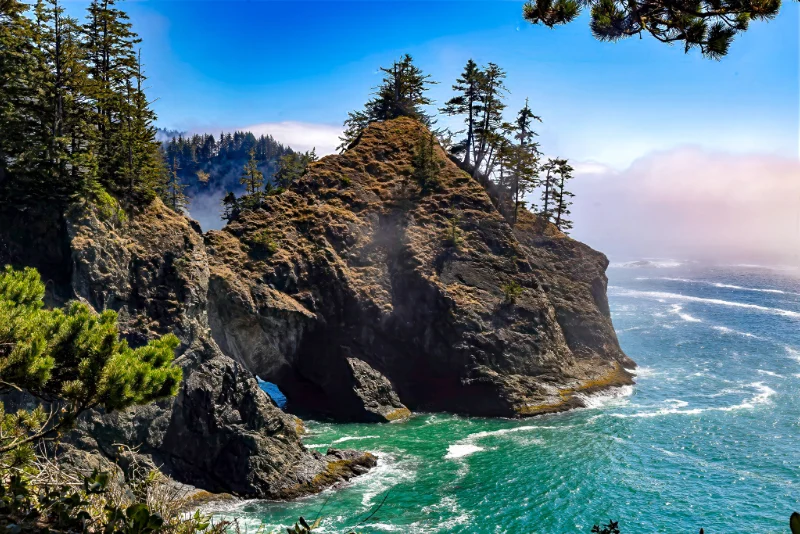
At the far southwestern corner of Oregon, the land does not slope gently into the sea. It ends in cliffs. This photograph captures that character: a wind-shaped headland, twisted evergreens, a drifting bank of fog, and surf churning turquoise against dark rock.
The Scene
A great buttress of rock rises from the water at the center of the frame. Its slopes are mottled with golden-brown grasses and lichen, and a few windblown conifers hold the crest, leaning slightly as if still bracing against the last storm. At the base, the sea has done patient work. A small arch opens near the waterline, and through it a sliver of blue shows from the other side.
The water around the rock is a vivid, glassy green. Swells run in from the open Pacific, break against the stone, and leave white streaks that spread across the surface. On the right, a soft bank of pink-tinged fog drifts over the horizon while the sky above it stays a clean, deep blue. In the foreground, dark pine branches and shore plants frame the view, as if you were standing on a cliffside trail looking out.
A Rocky Coast Shaped by Water
The scenery here matches the Samuel H. Boardman State Scenic Corridor, a 12-mile, forested, linear park with a rugged, steep coastline interrupted by small sand beaches, beginning about 4 miles north of Brookings. The shape of the land is the result of erosion.
The geology of this coast produces sheer cliffs, sea stacks, and natural arches, carved by wind and waves over long spans of time. One visitor’s account describes seaside prairies, spectacular vistas, secluded cove beaches, rugged cliffs and forested sea stacks coming one after the other throughout the park.
I can’t confirm the exact viewpoint from the image alone, so check it against your trip notes or GPS data before naming a specific spot.
Rock That Resists, Rock That Yields
The photograph shows both strength and change. The headland stands firm against constant surf, yet the arch at its base shows how the sea slowly wins. Waves find a crack, work into it, and widen it into a cave and then a tunnel. Given enough time, the rock above may collapse, leaving a sea stack standing alone offshore. What looks fixed in this frame is part of a very slow process, and the arch is a temporary feature of a landscape that is always being rearranged.
The trees tell a similar story. They grow where they can, rooted in thin soil and bent by salt-laden wind, and their shapes record years of weather. They give the rock scale, and they remind the viewer that life holds on even at the edge of the surf.
Saved for Everyone
The corridor is named for Samuel H. Boardman, the first Oregon Parks superintendent. He and others of his generation felt this shining coastline should be saved for the public, and today it remains open to anyone willing to walk its short trails and overlooks. Much of its appeal is that it still feels wild, with no wide promenades or crowded boardwalks, only rock, forest, and the sea.
The Oregon Coast Trail (OCT)
Oregon’s 362-mile coastline unfolds around every bend along the Oregon Coast Trail, also known as the OCT. Hikers cross sandy beaches, meander through forest-shaded corridors, traverse majestic headlands and pass through 28 coastal towns including the section where this photo was taken.
The Mood
The image rests on contrasts: bright turquoise against dark stone, soft fog against energetic surf, sturdy evergreens against a sea that never stops pushing. It offers both calm and energy. The cool colors of the water and sky settle the eye, while the rough texture of the headland gives it something to explore.
It is a view that rewards slowing down, the kind of place where you watch the waves for a few minutes and then notice you’ve been watching for an hour.
Reviews
There are no reviews yet.