• Crater Lake – Beautiful Blue

    Price range: $75.00 through $120.00

    Crater Lake National Park, Oregon

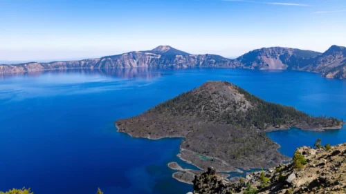
    High in the Cascade Range of southern Oregon, the land drops away to reveal one of the most startling sights in North America: a lake of such deep, saturated blue that it hardly looks real. Crater Lake fills the caldera of an ancient volcano, and this photograph captures the scene in its full scale and color.

    The Blue

    The first thing the eye finds is the water. Across the frame it shifts from pale, sky-reflecting blue near the far shore to a dense ultramarine in the foreground, so deep it almost looks like ink. The color comes from the lake's exceptional clarity and depth. Sunlight enters the water, the longer wavelengths are absorbed, and the blue light is scattered back to the surface. Crater Lake is the deepest lake in the United States, plunging nearly 2,000 feet, and the deeper the water, the richer the blue. Here the surface is nearly still, and soft reflections of the rim lie in a pale lavender band along the far shore.

    Wizard Island

    At the center of the image, a dark cone rises from the lake. This is Wizard Island, a volcanic cinder cone built by eruptions that continued after the main caldera formed. Its slopes are covered in dark volcanic rock and scattered conifers, and the summit crater at the top gives it a distinct, peaked shape. Around its edges, jagged lava rubble meets the water, and small pockets of turquoise glow where the shallows are lighter. The island sits like a stone ship on a sheet of blue, and it gives the vast scene a human-sized focal point.

    A Landscape Born of Catastrophe

    The beauty here comes from violence. About 7,700 years ago, a towering volcano called Mount Mazama erupted in a series of colossal explosions, emptying its magma chamber and collapsing in on itself. The result was a huge basin, roughly five to six miles across, with cliffs rising hundreds to a couple of thousand feet above the water. In the following centuries, rain and snowmelt filled it. No rivers flow in or out, so the lake is sustained almost entirely by what falls from the sky, which helps explain why the water is so remarkably pure. In the photograph, those caldera walls run across the background in layered bands of rust, gray, and soft violet. Slopes of loose scree spill toward the shore, and forested ridges and a distant peak mark the rim on the far side. A faint haze softens the horizon, and a few thin contrails trace across a pale blue sky.

    Life on the Rim

    In the lower right corner, a rocky slope of volcanic debris and hardy, wind-bent trees brings us back to the viewer's position on the rim. Up here, at more than 7,000 feet, the weather can change quickly and winter snow can run to many feet deep. Whitebark pine, mountain hemlock, and other tough species cling to the ground, and their dark green gives the cliffs a living edge.

    A Park Worth Protecting

    Crater Lake became a national park in 1902, one of the first in the country, and it remains a place of quiet awe. Visitors drive or cycle the rim road, hike to overlooks, and watch the light move across the water through the day. Early morning often brings calm surfaces and mirror reflections, while afternoon light sharpens the colors of the cliffs. This photograph holds all of it: the depth, the stillness, and the strange mix of fire and water that made the place. It is a reminder that some of the most beautiful landscapes are those that were shaped by upheaval.  
    Select options This product has multiple variants. The options may be chosen on the product page Details
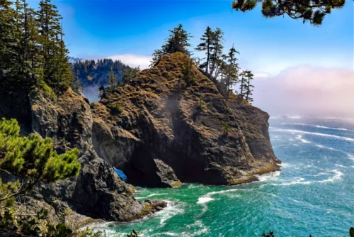
  • The Rocky Pacific Coast of Oregon

    Price range: $75.00 through $120.00

    Where the Forest Meets the Sea: The Rocky Coast Near Brookings, Oregon

    At the far southwestern corner of Oregon, the land does not slope gently into the sea. It ends in cliffs. This photograph captures that character: a wind-shaped headland, twisted evergreens, a drifting bank of fog, and surf churning turquoise against dark rock.

    The Scene

    A great buttress of rock rises from the water at the center of the frame. Its slopes are mottled with golden-brown grasses and lichen, and a few windblown conifers hold the crest, leaning slightly as if still bracing against the last storm. At the base, the sea has done patient work. A small arch opens near the waterline, and through it a sliver of blue shows from the other side.

    The water around the rock is a vivid, glassy green. Swells run in from the open Pacific, break against the stone, and leave white streaks that spread across the surface. On the right, a soft bank of pink-tinged fog drifts over the horizon while the sky above it stays a clean, deep blue. In the foreground, dark pine branches and shore plants frame the view, as if you were standing on a cliffside trail looking out.

    A Rocky Coast Shaped by Water

    The scenery here matches the Samuel H. Boardman State Scenic Corridor, a 12-mile, forested, linear park with a rugged, steep coastline interrupted by small sand beaches, beginning about 4 miles north of Brookings. The shape of the land is the result of erosion.

    The geology of this coast produces sheer cliffs, sea stacks, and natural arches, carved by wind and waves over long spans of time. One visitor's account describes seaside prairies, spectacular vistas, secluded cove beaches, rugged cliffs and forested sea stacks coming one after the other throughout the park.

    I can't confirm the exact viewpoint from the image alone, so check it against your trip notes or GPS data before naming a specific spot.

    Rock That Resists, Rock That Yields

    The photograph shows both strength and change. The headland stands firm against constant surf, yet the arch at its base shows how the sea slowly wins. Waves find a crack, work into it, and widen it into a cave and then a tunnel. Given enough time, the rock above may collapse, leaving a sea stack standing alone offshore. What looks fixed in this frame is part of a very slow process, and the arch is a temporary feature of a landscape that is always being rearranged.

    The trees tell a similar story. They grow where they can, rooted in thin soil and bent by salt-laden wind, and their shapes record years of weather. They give the rock scale, and they remind the viewer that life holds on even at the edge of the surf.

    Saved for Everyone

    The corridor is named for Samuel H. Boardman, the first Oregon Parks superintendent. He and others of his generation felt this shining coastline should be saved for the public, and today it remains open to anyone willing to walk its short trails and overlooks. Much of its appeal is that it still feels wild, with no wide promenades or crowded boardwalks, only rock, forest, and the sea.


    The Oregon Coast Trail (OCT)

     Oregon's 362-mile coastline unfolds around every bend along the Oregon Coast Trail, also known as the OCT. Hikers cross sandy beaches, meander through forest-shaded corridors, traverse majestic headlands and pass through 28 coastal towns including the section where this photo was taken.

    The Mood

    The image rests on contrasts: bright turquoise against dark stone, soft fog against energetic surf, sturdy evergreens against a sea that never stops pushing. It offers both calm and energy. The cool colors of the water and sky settle the eye, while the rough texture of the headland gives it something to explore.

    It is a view that rewards slowing down, the kind of place where you watch the waves for a few minutes and then notice you've been watching for an hour.

    Select options This product has multiple variants. The options may be chosen on the product page Details
Go to Top